Latest Post

Search

An Ice cave in Vatnajökull ice cap, southern Iceland.

Posted By Amazing World Online on Thursday 13 September 2012 | 21:04

#1
The Gateway to Iceland


Vatnajökull is the largest and most voluminous Icelandic glacier, and one of the largest in area in Europe, around 3,100 km³ constanly changing it's formation. It is located in the south-east part of the island, covering more than 8 percent of the country.


Under the ice cap there are several volcanoes, like many of the glaciers of Iceland. It´s quite hard to photograph the real depth of the ice inside the caves, but looking into the walls is like an endless 3d depth of blue ice. There is plenty of ash inside the cave, from the recent erupting volcano in Grímsvötn last spring.


According to Guinness World Records (GWR), Vatnajökull is the object of the world's longest sight line, 550 km (340 mi) from Slættaratindur, the highest mountain in the Faroe Islands. GWR states that "owing to the light bending effects of atmospheric refraction, Vatnajökull (2,109.6 m), Iceland, can sometimes be seen from the Faroe Islands, 340 miles (550 km) away".

#2

SURTSEY, Iceland : The emerging island

Posted By Amazing World Online on Wednesday 12 September 2012 | 01:14

#1
Off the coast of Iceland on the morning of 14 November 1963, the crew of a lone fishing trawler spotted an alarming sight. Off to the southwest of the Ísleifur II, a column of dark smoke was rising from the water. Concerned that it could be another boat on fire, the captain directed his vessel towards the scene. Once there, however, they found not a boat but a series of violent explosions producing ash. This was an unmistakable indication of a volcanic eruption taking place underwater, close to the surface. Very aware of the potential danger but eager to watch, the crew kept their boat nearby. It was indeed a remarkable event that they would witness a small part of over the course of that morning: the formation of a brand-new island.


Although now quite visible, the eruption lasted for much, much longer than the Ísleifur II would have been able to watch. After several days, the volcano had broken the water’s surface, forming an island over 500 meters long and 45 meters tall. Even though the rough tides of the North Atlantic might have soon eroded the new island away, it was named Surtsey, meaning ‘Surtur’s island’ – Surtur (or Surtr) being a fire giant of Norse mythology. The island proved to be tenacious, however. The eruption was ongoing and Surtsey increased in size more quickly than the ocean could wear it down. In the meantime two other nearby volcanic eruptions produced the beginnings of islands, but neither lasted very long. By April 1964, though, the most violent parts of the eruption were over and Surtsey remained.


#2

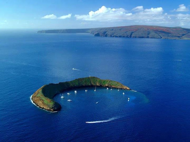
The Crescent-Shaped Molokini Crater in Hawaii.

Posted By Amazing World Online on Sunday 9 September 2012 | 03:44

#1

Molokini is a partially sunken volcanic crater just 2.5 miles off the coast of Maui, Hawaii. Located between the islands of Maui and Kahoolawe, Molokini is now a beautiful underwater sanctuary for marine life. Molokini is truly one of Maui’s most breathtaking snorkel and dive locations. Part of Maui County, Molokini is a popular destination for scuba diving and snorkeling with many tourist boats coming each day from the south coast of Maui.

This exotic location is designated as a Hawaii State Marine Life and Bird Conservation District. To protect the reef, the Hawaii State Division of Boating and Recreation established mooring buoys for Molokini.
Molokini: One of the Top Ten Dive Spots
The crescent shape provides protection from waves and ocean currents making this area one of the top ten dive sites in the world. Molokini’s back wall drops off to depths of 300 feet. Inside the crescent shape is a reef area with clear views to 150 feet. These waters are home to about 250 species of fish.
Molokini, an uninhabited island, has a land mass of just 23 acres.


#2

Amazing Creativity With Nature

Posted By Amazing World Online on Monday 3 September 2012 | 17:48

#1

Amazing Creativity with Nature


Image Source ~  paktrendz.com
#2

Mammatus Clouds - Rare Atmospheric Phenomenon

Posted By Amazing World Online on Saturday 1 September 2012 | 23:16

#1

Mammatus, also known as mammatocumulus  is a meteorological term applied to a cellular pattern of pouches hanging underneath the base of a cloud.


Sometimes very ominous in appearance, mammatus clouds are harmless and do not mean that a tornado is about to form It is a commonly held misconception that tornado is about to form when mammatus clouds form. In fact, mammatus are usually seen after the worst of a thunderstorm has passed.


The subsiding air eventually appears below the cloud base as rounded pouch-like structures called mammatus clouds.


#2


Disclaimer
Privacy Policy
Contact Us


Proudly powered by Blogger
Copyright © 2013. Amazing World Online - All Rights Reserved.