Latest Post

Search

Niue: the Pacific Island paradise

Posted By Kirti Ranjan Nayak on Sunday 6 January 2013 | 19:05

#1


Niue is a South Pacific Ocean Island country, 2,400 kilometres (1,500 mi) northeast of New Zealand and within the triangle formed by Tonga (to the southwest), the Samoas (to the northwest) and the Cook Islands (to the southeast). Its one of the smallest countries on earth and the largest raised coral atoll in the world.


Its land area is 260 square kilometres (100 sq mi) and its population is around 1,400. They commonly refer to the island as "the Rock", a reference to the traditional moniker "Rock of Polynesia". Niue is in free association with New Zealand, and most of its diplomatic relations are conducted by New Zealand on Niue's behalf. All Niueans are New Zealand citizens.


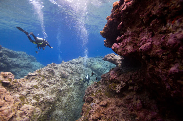
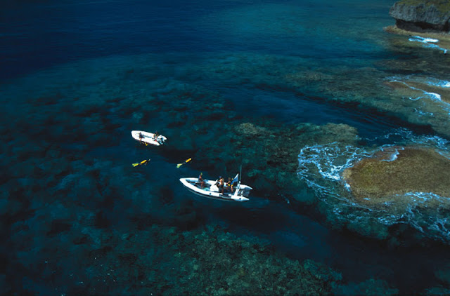
With world class diving, fishing, walking, caving and whale interactions set in a relaxing tropical environment, Niue is a place for soft adventure and ecotourism paradise. It’s a place where nature hasn’t been broken and things are the way ‘they used to be’. Swim with whales and dolphins, dive within underwater caverns in crystal clear water, discover your own secluded sandy cove teeming with coloured fish, snorkel over bright coral in warm waters and explore breathtaking caves with ease.


Niue is also one of the world’s safest destinations and one of the few countries in the world where crime is almost unheard of. It’s also free of any harmful animals or insects !

In 2003, Niue became the world's first "wi-fi nation", in which free wireless Internet access is provided throughout the country by The Internet Users Society-Niue.

Coral chasm in Niue
Coral chasm in Niue

Credits: www.niueisland.com  and more at: Wikipedia
#2

The World's Largest Ice Cave in Salzburg, Austria

#1
THE LARGEST ICE CAVE IN THE WORLD:  "EISRIESENWELT" (Austria)


One of the true wonders on earth, the Eisriesenwelt caves are a wondrous underground world of natural ice sculptures and formations and the largest of its kind. Eisriesenwelt means "world of the ice giants" in German.

Its is a labyrinth of natural limestone ice caves, located within the Hochkogel mountain in the Tennengebirge section of the Alps, in Werfen, Austria, about 40 km south of Salzburg, and stretch for a remarkable 40 kilometers. Only the first kilometer is covered in ice, thats the area that tourists are allowed to visit, but it's enough to get a feel of what the remaining network would be like: a truly mesmerizing art of nature's handicraft. The rest of the cave is formed of limestone. The cave is open to tourists from May 1st to October 26th every year.


There are various ways in which a cave ice can form. The Eisriesenwelt is a dynamic cave, which means the corridors and the crevices connect lower lying entrances to higher openings, thus it makes it possible for draughts of air to circulate – similar to the effect in a chimney. During spring, melt water seeps through the cracks in the rock and when it reaches the still cold and frozen lower areas of the caves it freezes and turns slowly into the wonderful ice formations visible inside the caves.


Eisriesenwelt was formed by the Salzach river, which eroded passageways into the mountain. The ice formations in the cave were formed by thawing snow which drained into the cave and froze during winter. Since the entrance to the cave is open year-round, chilly winter winds blow into the cave and freeze the snow inside. In summer, a cold wind from inside the cave blows toward the entrance and prevents the formations from melting.


The first official discovery of Eisriesenwelt was by "Anton Posselt", a natural scientist from Salzburg, in 1879, though he only explored the first two hundred meters of the cave. Before his discovery, the cave was known only to locals who believed that it was an entrance to Hell and refused to explore it. "Alexander von Mork", a speleologist from Salzburg led several expeditions into the caves beginning in 1912, which were soon followed by other explorers.


 Eisriesenwelt cave fetches around 200,000 tourists every year.

#2

"Chasing Ice" movie reveals largest iceberg break-up ever filmed

Posted By Kirti Ranjan Nayak on Friday 14 December 2012 | 01:40

#1

It's like watching 'Manhattan breaking apart in front of your eyes', says one of the researchers for filmmaker James Balog. He's describing the largest iceberg calving ever filmed, as featured in his movie, Chasing Ice. After weeks of waiting, the filmmakers witnessed 7.4 cubic km of ice crashing off the Ilulissat glacier in Greenland. 

Check out this Unbelievable  Video..!!


Acclaimed photographer James Balog was once a skeptic about climate change. But through his Extreme Ice Survey, he discovers undeniable evidence of our changing planet. Here's the trailer.

#2

Skellig Michael: The monastery in the middle of the sea

Posted By Kirti Ranjan Nayak on Thursday 13 December 2012 | 05:48

#1
Skellig Michael or Great Skellig is an island in the Atlantic Ocean, 11.6 km west of the Iveragh Peninsula in County Kerry, Ireland. A Christian monastery was founded on the island at some point between the 6th and 8th century, and was continuously occupied until its abandonment in the late 12th century. The remains of this monastery, along with most of the island itself, were inscribed on the UNESCO World Heritage List in 1996.


Each year 13 boat licenses are granted to tour operators who each run a single trip to Skellig Michael each day during the summer season (April to October, inclusive), weather permitting. For safety reasons, because the steps up to the monastery are rock, steep, and old, climbs are not permitted during very wet or windy weather. There are also dive sites immediately around the rock


Hardy tourists visit the island of Skellig Michael, off the Ring of Kerry, where monks helped keep literacy alive in the Dark Ages.
The grave yards
 Source: Wikipedia
#2

Aurora Borealis - Northern Lights: A wonder of Nature..!!!

Posted By Unknown on Tuesday 4 December 2012 | 22:27

#1
An Aurora is a light display in the sky which is natural particularly in the high latitude regions. It is caused by the collision of energetic partials with the atoms in the high altitude. Charged particles are directed to Earth by the Earth magnetic field into the atmosphere, they originate in magnetosphere and solar wind and on Earth.


The effect is known as Aurora Borealis or Northern Lights usually occurs in Northern latitudes. In southern Hemisphere, its called  Aurora Australis (or the Southern Lights). Aurora is named after the Roman goddess of dawn where as Boreas is Greek name for the north wind. Northern lights have different names i.e Cree call this phenomenon the "Dance of Spirits". Aurorae also occurs in Other Planets as well which is almost similar to the Earth's aurora and they are visible near Planet's magnetic poles.


Auroras is a result of emission of photons in the earth's upper atmosphere above 80 km when atoms of Nitrogen and Oxygen return from excited state to ground state and  ionized nitrogen atoms regaining an electron. One of the most spectacular in recent history auroras that was resulted from the "great geomagnetic form" on 28 August and 2 September 1859. Solar wind flowing past the Earth is the ultimate energy source of the Aurora. It has been also proved that Aurora Borealis  produces static-like sound which comes from the solar particles associated with creating aurora.


#2

20th Century's 2nd Largest Volcanic Eruption

Posted By Unknown on Wednesday 28 November 2012 | 20:28

#1
In Luzon, Philippines volcanic eruption took place which was second largest of the twentieth century. This location is approximately 55 miles northwest of the capital of Philippines - Manila. Almost 100,000 people became homeless and nearly 800 people were killed. On 15 June 1991 eruption from Mount Pinatubo took place for long 9 hours which cause millions of tons of sulfur dioxide discharged into the atmosphere, vast quantities of minerals and metals to the surface environment, which decreased the global temperature by about 0.5 Degrees C and increased the ozone depletion temporary.


Mount Pinatubo is located in Cabusilan Mountains. Activities in Ancestral Pinatubo had begun almost 1.1 million years ago and ended nearly tens of thousands or more before the birth of new 'Modern Pinatubo'. It's center was roughly same location. Before eruption height of Mount Pinatubo was 1,745 meters above sea level and now the height of Mount Pinatubo is almost 2,300 meters above sea level. Mount Pinatubo experienced other major eruptions nearly 5500, 3000 and 500 years before.


It is estimated that the eruption ejected about 2.4 cubic meter of material which was 10 times larger than the 1980 Mount St Helens eruption. Total area of about 37,000 acres which was valued at 125 million pesos were destroyed. 200,000 acres of rice growing farms were destroyed. this eruption caused a loss of about 1.5 billion pesos to agriculture. Total loss due to this eruption were estimated around 10.6 billion pesos.


#2

Sunrise at Mount. Kailash..

Posted By Kirti Ranjan Nayak on Wednesday 21 November 2012 | 21:54

#1

Mount Kailash,Gangs Rin-po-che, meaning "precious jewel of snows" ( གངས་རིན་པོ་ཆེ། ) 


Mt. Kailash is a holy mountain in western Tibet.

It lies near the source of some of the longest rivers in Asia: the Indus River, the Sutlej River (a major tributary of the Indus River), the Brahmaputra River, and the Karnali River (a tributary of the Ganges River). It is considered a sacred place in four religions: Bön, Buddhism, Hinduism and Jainism.
Elevation 6,638 m (21,778 ft)
Source: Wikipedia

Slideshow of Kailash Kora Set  - Click here -


Every year, thousands make a pilgrimage to Mt. Kailash, following a tradition going back thousands of years. Pilgrims of several religions believe that walking around Mount Kailash on foot is a holy ritual that will bring good fortune. This is done in a clockwise direction by Hindus and Buddhists. In the Hindu tradition the spiritual centre of the Universe is represented by Mount Kailas. The Buddhist tradition calls the Sacred Mountain as Mount Meru which again is a symbol of the highest point in the spiritual Universe from where the whole of Creation can be contemplated. It is called Meru or Sumeru, according to the oldest Sanskrit tradition. Followers of the Jain and Bönpo religions circumambulate the mountain in a counterclockwise direction. 

The path around Mount Kailash is 52 km (32 mi) long. Some pilgrims believe that the entire walk around Kailash should be made in a single day. This is not easy. A person in good shape walking fast would take perhaps 15 hours to complete the 52 km trek. Some of the devout do accomplish this feat, little daunted by the uneven terrain, altitude sickness and harsh conditions faced in the process.

Indeed, other pilgrims venture a much more demanding regimen, performing body-length prostrations over the entire length of the circumambulation: The pilgrim bends down, kneels, prostrates full-length, makes a mark with his fingers, rises to his knees, prays, and then crawls forward on hands and knees to the mark made by his/her fingers before repeating the process. It requires at least four weeks of physical endurance to perform the circumambulation while following this regimen. The mountain is located in a particularly remote and inhospitable area of the Tibetan Himalayas. A few modern amenities, such as benches, resting places and refreshment kiosks, exist to aid the pilgrims in their devotions.

Walking around the holy mountain has to be done on foot, pony or yak; it takes three days of trekking starting from a height of around 15,000 ft to crossing the Dolma pass (19,000 ft) and encamping for two nights en route. First, near the meadow of Dirapuk gompa—2 or 3 km before the pass and second, after crossing the pass and going downhill as far as possible (viewing Gauri Kund in the distance).


#2

LIGHT PILLAR PICTURES: Mysterious Sky Shows

Posted By Kirti Ranjan Nayak on Monday 19 November 2012 | 15:31

#1
Light pillars appear as eerily upright luminous columns in the sky, beacons cast into the air above without an apparent source.. 

A light pillar is a visual phenomenon created by the reflection of light from ice crystals with near horizontal parallel planar surfaces. The light can come from the Sun (usually at or low to the horizon) in which case the phenomenon is called a sun pillar or solar pillar. It can also come from the Moon or from terrestrial sources such as streetlights


Light pillars are a kind of optical phenomenon which is formed by the reflection of sunlight or moonlight by ice crystals that are present in the Earth’s atmosphere, or from artificial ground sources such as street or park lights.
The light pillar looks like a thin column that extends vertically above and/or below the source of light. The light pillar is prominently visible when the Sun is low or lies below the horizon. It normally forms an arc that extends from five to ten degrees beyond the solar disc. Light pillars can sometimes also be seen arising from the Moon.


Source: Wikipedia
#2

The Victoria Falls: the Smoke that Thunders [VIDEO]

Posted By Kirti Ranjan Nayak on Sunday 18 November 2012 | 17:16

#1

The Victoria Falls or Mosi-oa-Tunya (Tokaleya Tonga: the Smoke that Thunders) is a waterfall located in southern Africa on the Zambezi River between the countries of Zambia and Zimbabwe.

While it is neither the highest nor the widest waterfall in the world, it is claimed to be the largest. This claim is based on a width of 1,708 metres (5,604 ft) and height of 108 metres (354 ft), forming the largest sheet of falling water in the world. 

Most of the tourists from all across the world enjoy their vacations with their family members in the lapse of these huge water curtains. The great Victoria Falls of South Africa are one of the Seven Wonders of the World today. 


The water falls also includes the weathered rock pieces which crumble down into the Zambezi Gorge below. The falling water of these extremely gigantic curtains creates a cloudy atmosphere and a foggy appearance at a height of 450 meters above the sea level. This foggy view can be clearly observed by the tourists at a distance of 40 kms away from these falls and it mainly attracts the tourists towards itself.
The tourists can enjoy the mesmerizing splendor and beauty of these falls throughout the year. The temperature is mostly humid and moderate which is best suited to attract a large no of tourists towards its attractiveness. The cascading chilled water of these waterfalls depends on the amount of rain fall which took place throughout the year and it also depends on the catchment area of the River Zambezi. As the catchment area of Zambezi River expands, the amount of water in the river also increases.
These exotic waterfalls offer many attractions to the tourists like water surfing, river rafting and river boarding. The Victoria Falls along with the nearby landscapes have been declared as the world heritage site. It is really a captivating destination where you can seriously enjoy a couple of days and make your vacations memorable.
Source: Travlang

Victoria Falls [VIDEO] 


Copyright 2007 - Playomatic Media Group

#2

Kjeragbolten boulder: Afraid of heights? This will make your knees shudder [VIDEO]

Posted By Kirti Ranjan Nayak on Saturday 3 November 2012 | 13:54

#1
The Kjeragbolten boulder is a huge rock wedged more than 1000 meters up between two cliff faces. The boulder is situated in the Kjerag mountain, in Norway.


Rumours say that the rock got stuck there sometime during the last ice age. Today, it’s one of the most popular places to get your picture taken.  Even though the boulder hangs more than a kilometer above the water below, and there’s no hand rail or safety net, people walk (in some cases, crawl) out onto the rock for a photo shoot. Evidently the rock’s surface is flat enough that walking out onto it is relatively easy. Just mind your steps and don’t look down. If you get dizzy, you lose your balance and fall into the chasm below.


This area of Norway is absolutely gorgeous! Kjeragbolten is reachable from the Kjerag plateau, a peak that towers above all others in the Lysefjord area. The plateau has become a popular BASE jumping site. But several BASE jumping accidents happen here each year, and BASE jumping from the plateau may eventually become illegal. But if you don’t plan to jump from the plateau, you can simply take in an incredible view of the blue fjords below, the surrounding mountain cliffs, and, weather permitting, an azure sky. The climb to the plateau isn’t easy. The hike is a short 3.6 miles (6 kilometers), but it’s a vertical one; there’s an elevation change of 1,500 feet (500 meters) between start and finish.
To add to the intrigue of the Kjerag mountain, there’s a place near the summit where you’ll hear the sound of a pistol and even see smoke. It’s not a ghost shooting at you. It’s just the wind, blowing in from the east.
Source: Howstuffworks
These Base Jumpers are Amazingly Daring.. Check this VIDEO out. 

-

#2

AMAZING MUSHROOM STORM CLOUD OVER BEIJING

Posted By Kirti Ranjan Nayak on Friday 2 November 2012 | 15:20

#1

This incredible mushroom-like cumulonimbus storm cloud was spotted on 15th June over Beijing skies. As a plane flies through it, it gives us a great indication of how massive this cloud in real is. Apparently this gigantic cloud took over 70 minutes to form and was followed by quite a storm.
#2

DRAMATIC MOSS COVERED WATERFALL IN ROMANIA

Posted By Kirti Ranjan Nayak on Tuesday 30 October 2012 | 21:34

#1
This is the Bigar Cascade Falls in Carass Severin, Romania. The dramatic moss-covered falls are situated in the forests of the Anina Mountains and is formed by an underground water spring that spills into the Minis River.


Photograph by SANDRA RUGINA (behindmyblueeyes @ etsy.com)
Looks really Peaceful. 


#2

Rio Secreto: Underground river in Riviera Maya, Mexico

Posted By Amazing World Online on Saturday 15 September 2012 | 10:47

#1

Rio Secreto: Mexico's Secret River


Rio Secreto is a new tourist attraction in the Riviera Maya that thrills visitors with a visit to a natural underground river and the limestone cavern system it winds through. Discovered in 2007, the cave is part of a 7.5-mile long network that is still being explored and mapped.

Most underground river networks such as these are limited to trained spelunkers, since there are sections completely underwater that require diving equipment. Rio Secreto, however, can be experienced on foot in a few hours -- with no swimming experience required -- and enjoyed by all ages.
 
The caves and cenotes of the Yucatan have figured in Mayan religious ceremonies for centuries, and Moses shared an extensive knowledge and passion for the history, spiritual significance and environmental importance of this unique underworld environment. Along the way you will see and learn about stalagmites and stalactites, natural limestone columns, cathedral-like ceilings, and the small wildlife that inhabits the caves, such as bats and small fish. (Some visitors may think they see snakes on the paths, but these are only roots that wind along the cave floor.)
#2


Disclaimer
Privacy Policy
Contact Us


Proudly powered by Blogger
Copyright © 2013. Amazing World Online - All Rights Reserved.